Welcome to the Jefferson County Javascript map viewer
This application will work on all computers, phones and tablets.
(Javascript MUST be enabled)
Data Copyright 2020 by the Jefferson County GIS/Addressing Office, All Rights Reserved.
Map navigation using mouse and keyboard:
Drag to pan
SHIFT + Click to recenter
SHIFT + Drag to zoom in
SHIFT + CTRL + Drag to zoom out
Mouse Scroll Forward to zoom in
Mouse Scroll Backward to zoom out
Use Arrow keys to pan
+ key to zoom in a level
- key to zoom out a level
Double Click to Center and Zoom in
The Jefferson County Maps and Data are provided by the Jefferson County GIS/Addressing Office to allow for easy access and a visual display of County information only. Every reasonable effort has been made to ensure the accuracy of the maps and data provided; nevertheless, some information may not be accurate. The Jefferson County GIS/Addressing Office assumes no responsibility arising from the use of this information.
THE MAPS AND ASSOCIATED DATA ARE PROVIDED WITHOUT WARRANTY OF ANY KIND, either expressed or implied, including but not limited to, the implied warranties of merchantability and fitness for a particular purpose. Do not make any business or personal decisions based on data before validating your decision with the appropriate County office.
Jefferson County GIS Maps are only used for general reference purposes and are not legal maps. They may not be used as a substitute for survey plats and may not be attached to a legal document to represent a property's actual shape or size, since they only reflect the general location, shape, and size of properties within Jefferson County and may not be accurate.
Maps from this site may not be made available for resale by any person(s) or business for any reason and permission to do so will not be granted.
This application was created by:
David Spriggs
Copyright (c) 2014
and used under the MIT License
Modified By Jessica Gormont
Data Copyright 2020 by the Jefferson County GIS/Addressing Office, All Rights Reserved.
Topo - ESRI Topo Map
Satellite - Thrasher Engineering (Spring 2020)
The Layer Menu item allows the selection of the layers to be displayed by checking the box beside that layer.
The beside the checkbox allows you to see the symbolization for the layer.
The Menu lines allow you to change the order of the layers displayed (move up or down), zoom to that layer (not really functional on this map since all layers contain the entire county it will zoom to the county level, and allows you to set the transparency of the layer.
The Identify Menu item allows the selection of the layers who's data will be shown when you click on the parcel. The layer must be checked in the layer menu to show up in the drop box.
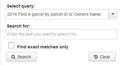
The Find Menu item allows you to search the layers for data.
Select query: Selects the layer you wish to seach.
Search for: Enter the text you wish to search for here.
Find exact matches only will only find exact matches when checked.
executes the search when clicked.
Clears the search and resets it back to default when clicked.
Searches the 2016 tax map layer.
It searches for Parcel ID number in either form (08 2000500000000 or 08000200050000)
It searches for Owner name (last first)
It searches Legal description sp that you can search for a lot in Shannondale by searching shanondale and finding the lot in the result.
It also searches by Owner address (IE the address where the county sends the tax bill) This is NOT necessarily the physical address if the property.
Searches the 2015 tax map layer.
It searches for Parcel ID number in either form (08 2000500000000 or 08000200050000)
It searches for Owner name (last first)
It searches Legal description sp that you can search for a lot in Shannondale by searching shanondale and finding the lot in the result.
It also searches by Owner address (IE the address where the county sends the tax bill) This is NOT necessarily the physical address if the property.
Searches the 911 address layer.
It searches for a full address IE: 100 E Main St or 100 E Main.
It searches for Street name. IE search for Burns returns all parcels on Burns St.
The means the tool is floatable. Simply click on the Find Bar and drag it to the map. To return the tool to the menu click the
The measurment tool allows you to measure features.
**** Warning when using this tool, as stated in the disclaimer, these are tax maps with are a generality of the parcels in the county. They are NOT survey accurate and never will be. DO NOT use this tool as a substitute for a survey. The results are NOT accurate. DO NOT try to locate your corners with the point tool. Consumer grade GPS units are only capable, under ideal conditions, of 15 meter accuracy. Cell Phones are even worse. You MUST have a license to survey in the state of West Virginia. Setting corners is illegal unless you are licensed. Any use of this tool for other than general informational purposes will result in the tool being removed from the site. ****
The measures area
The measures distance
The give latitude and logitude points
Results are show in the Measurement results area:
The means the tool is floatable. Simply click on the Measurment Bar and drag it to the map. To return the tool to the menu click the